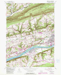
1954 Map of Mifflinville
USGS Topo · Published 1989About this map
The Susquehanna River cuts through this portion of Columbia County, separating the riverfront village of Mifflinville (Creasy Sta) from the industrial and residential pockets of Lime Ridge and Briar Creek. The landscape transitions from the river valley to the steep slopes of Lee Mountain and Orange Knob, where State Game Lands No 55 dominates the northern ridge. The map reveals a dense network of local history, from the Covered Bridge on Fishing Creek to the cluster of specialized burial grounds near Berwick, including the Russian Orthodox Cem and Greek Catholic Cem. This area reflects a mid-century period of transition where early settlement patterns, represented by Dennis Mills and Pealertown, meet modern transportation infrastructure like Interchange 36 and several stretches of Railroad Grade documenting the region's evolving rail dependency.
Find a feature on this map
57 named features on this map. Tap any name to fly to it.
Don’t see what you’re looking for? This feature index may not catch every label — zoom into the map to look around manually.
Map Details
Editions of this 1954 Mifflinville Map
4 editions found
Other maps of this area

1889 · Catawissa
USGS Topo · 1:62,500

1892 · Catawissa
USGS Topo · 1:62,500

1892 · Mahanoy
USGS Topo · 1:62,500

1893 · Mahanoy
USGS Topo · 1:62,500

1894 · Catawissa
USGS Topo · 1:62,500

1894 · Shickshinny
USGS Topo · 1:62,500

1894 · Bloomsburg
USGS Topo · 1:62,500

1946 · Shickshinny
USGS Topo · 1:31,680

1946 · Berwick
USGS Topo · 1:31,680

1947 · Bloomsburg
USGS Topo · 1:24,000