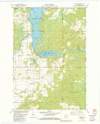
1981 Map of Mikana
USGS Topo · Published 1982About this map
Red Cedar Lake dominates this northern Wisconsin landscape, its waters dotted with numerous named landforms including Stout Island, Honeymoon Island, and Faust Island. The settlement of Mikana sits on the western shore, positioned where the Red Cedar River flows south, while the small junction of Loveland Corners marks the transition toward the marshier terrain to the east. Transportation patterns here reflect a shifting era, with the Tuscobia Park Falls State Trail occupying a former rail corridor, identified on the map as an Old Railroad Grade.
Find a feature on this map
38 named features on this map. Tap any name to fly to it.
Don’t see what you’re looking for? This feature index may not catch every label — zoom into the map to look around manually.
Map Details
Editions of this 1981 Mikana Map
This is the sole edition of this map. No revisions or reprints were ever made.
Other maps of this area

1945 · Meteor
USGS Topo · 1:48,000

1948 · Weyerhauser
USGS Topo · 1:48,000

1949 · Meteor
USGS Topo · 1:48,000

1949 · Rice Lake
USGS Topo · 1:48,000

1950 · Weyerhauser
USGS Topo · 1:48,000

1951 · Rice Lake
USGS Topo · 1:48,000

1951 · Chetek
USGS Topo · 1:62,500

1953 · Rice Lake
USGS Topo · 1:250,000

1959 · Rice Lake
USGS Topo · 1:250,000

1965 · Rice Lake
USGS Topo · 1:62,500