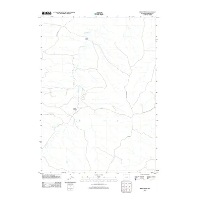
2012 Map of Mikes Draw
USGS Topo · Published 2012About this map
Twentymile Cr winds through this corner of Niobrara County, shaping the drainage patterns and terrain of the High Plains landscape. The area is defined by its subtle but distinct topographical depressions, most notably the eponymous Mikes Draw in the north and the jagged contours of Cedar Canyon further south. This 2012 survey by the U.S. Geological Survey reflects a sparsely populated ranching environment where the transportation network is limited to a few primary thoroughfares such as Lightning Creek Rd, 20 Mile Rd, and Divide Rd. The map illustrates the fundamental relationship between water and land use in this arid region, where the intermittent flow of creeks dictates the placement of roads and the boundaries of large-scale land holdings in eastern Wyoming.
Find a feature on this map
6 named features on this map. Tap any name to fly to it.
Don’t see what you’re looking for? This feature index may not catch every label — zoom into the map to look around manually.
Map Details
Editions of this 2012 Mikes Draw Map
This is the sole edition of this map. No revisions or reprints were ever made.
Other maps of this area

1954 · Torrington
USGS Topo · 1:250,000

1955 · Newcastle
USGS Topo · 1:250,000

1958 · Torrington
USGS Topo · 1:250,000

1958 · Newcastle
USGS Topo · 1:250,000

1970 · Lost Springs NW
USGS Topo · 1:24,000

1970 · Cooley Draw
USGS Topo · 1:24,000

1981 · Mercer Draw
USGS Topo · 1:24,000

1981 · Lance Creek NW
USGS Topo · 1:24,000
1981 · Split Hill SW
USGS Topo · 1:24,000
1981 · Lance Creek
USGS Topo · 1:24,000