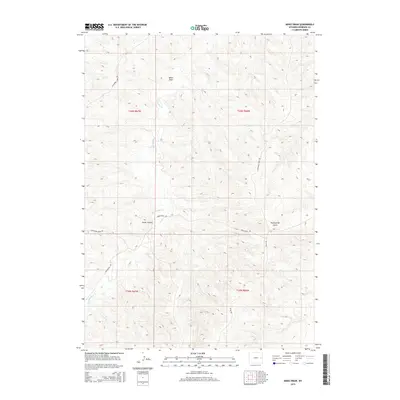
2015 Map of Mikes Draw
USGS Topo · Published 2015About this map
Twentymile Cr meanders through the heart of this high plains landscape in Niobrara County, shaping the local topography of deep draws and canyons. The drainage network is defined by significant natural depressions like Mikes Draw and Twentymile Gulch, which illustrate the erosion patterns characteristic of this part of eastern Wyoming. Human presence in this area is primarily marked by a sparse network of section-line and topographic roads. Lightning Creek Rd and Twentymile Rd serve as the primary conduits across the terrain, reflecting a ranching or resource-based land use pattern where transportation follows the natural contours of the land. Cedar Canyon provides a prominent landmark within the township grid system of t36n r67w and surrounding surveyed blocks, offering a clear view of the area's geological structure as it stood in the early 21st century.
Find a feature on this map
11 named features on this map. Tap any name to fly to it.
Don’t see what you’re looking for? This feature index may not catch every label — zoom into the map to look around manually.
Map Details
Editions of this 2015 Mikes Draw Map
This is the sole edition of this map. No revisions or reprints were ever made.
Other maps of this area

1954 · Torrington
USGS Topo · 1:250,000

1955 · Newcastle
USGS Topo · 1:250,000

1958 · Torrington
USGS Topo · 1:250,000

1958 · Newcastle
USGS Topo · 1:250,000

1970 · Lost Springs NW
USGS Topo · 1:24,000

1970 · Cooley Draw
USGS Topo · 1:24,000

1981 · Mercer Draw
USGS Topo · 1:24,000

1981 · Lance Creek NW
USGS Topo · 1:24,000
1981 · Split Hill SW
USGS Topo · 1:24,000
1981 · Lance Creek
USGS Topo · 1:24,000