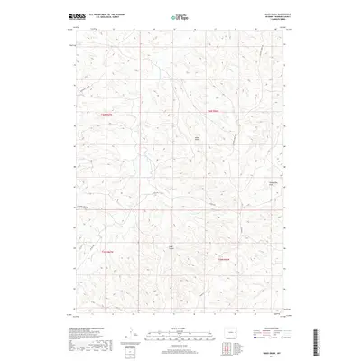
2017 Map of Mikes Draw
USGS Topo · Published 2017About this map
Twentymile Cr and Lightning Creek carve through the high plains of Niobrara County, defining a landscape of erosion and drainage in this corner of eastern Wyoming. This 2017 survey illustrates the sparse but critical network of ranching roads that crisscross the terrain, including Lightning Creek Rd and 20 Mile Rd. The topography is dominated by dramatic natural depressions and drainages such as Mikes Draw, Twentymile Gulch, and Cedar Canyon, which follow the natural contours of the land toward the larger creek beds.
Find a feature on this map
13 named features on this map. Tap any name to fly to it.
Don’t see what you’re looking for? This feature index may not catch every label — zoom into the map to look around manually.
Map Details
Editions of this 2017 Mikes Draw Map
This is the sole edition of this map. No revisions or reprints were ever made.
Other maps of this area

1954 · Torrington
USGS Topo · 1:250,000

1955 · Newcastle
USGS Topo · 1:250,000

1958 · Torrington
USGS Topo · 1:250,000

1958 · Newcastle
USGS Topo · 1:250,000

1970 · Lost Springs NW
USGS Topo · 1:24,000

1970 · Cooley Draw
USGS Topo · 1:24,000

1981 · Mercer Draw
USGS Topo · 1:24,000

1981 · Lance Creek NW
USGS Topo · 1:24,000
1981 · Split Hill SW
USGS Topo · 1:24,000
1981 · Lance Creek
USGS Topo · 1:24,000