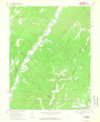
1967 Map of Milam
USGS Topo · Published 1969About this map
The South Fork Potomac River and its upper branches carve through the highlands of the George Washington National Forest along the West Virginia and Virginia border. In the late 1960s, small settlements such as Milam and Peru served as local centers for the valley communities, while several country churches including Mt Olive Ch and Zion Ch anchored the social landscape. The terrain is defined by prominent ridges like Shenandoah Mountain and Milroy Mountain, which separate the river drainage from the Sweedlin Valley. Along the eastern edge, the village of Criders sits near the German River, illustrating the pocketed nature of Appalachian settlement. This survey reveals the winding path of South Branch Potomac River and the numerous named mountain runs that supported these remote farmsteads and timberlands.
Find a feature on this map
42 named features on this map. Tap any name to fly to it.
Don’t see what you’re looking for? This feature index may not catch every label — zoom into the map to look around manually.
Map Details
Editions of this 1967 Milam Map
2 editions found
Other maps of this area

1892 · Franklin
USGS Topo · 1:125,000

1892 · Woodstock
USGS Topo · 1:125,000

1896 · Franklin
USGS Topo · 1:125,000

1920 · Petersburg
USGS Topo · 1:48,000

1921 · Orkney Springs
USGS Topo · 1:48,000

1921 · Petersburg
USGS Topo · 1:48,000

1922 · Fort Seybert
USGS Topo · 1:48,000

1922 · Petersburg
USGS Topo · 1:62,500

1923 · Orkney Springs
USGS Topo · 1:62,500

1924 · Fort Seybert
USGS Topo · 1:62,500