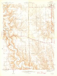
1946 Map of Milan
USGS Topo · Published 1946About this map
Laughery Creek carves a winding path through the heart of this mid-century survey, creating a dramatic landscape of steep ridges and deep valleys that define Versailles State Park. The map documents a predominantly rural township structure where small social hubs like Stringtown and Elrod are anchored by local institutions such as Stringtown Sch and Zion Ch. The upland plateaus are dotted with numerous family and community burial grounds, including the Wilson Cem and Henderson Cem, which serve as vital markers for genealogical research in this part of Ripley County. In the northeast corner, the town of Milan sits at a higher elevation, showing its residential layout and rail connection. The western portion is dominated by the park's terrain, highlighted by a Fire Tower overlooking the sharp oxbows of the creek below, illustrating the conservation efforts of the State of Indiana Department of Conservation.
Find a feature on this map
29 named features on this map. Tap any name to fly to it.
Don’t see what you’re looking for? This feature index may not catch every label — zoom into the map to look around manually.
Map Details
Editions of this 1946 Milan Map
2 editions found
Other maps of this area

1946 · Versailles
USGS Topo · 1:24,000

1946 · Milan
USGS Topo · 1:24,000

1946 · Pierceville
USGS Topo · 1:24,000

1946 · Osgood
USGS Topo · 1:24,000

1953 · Cincinnati
USGS Topo · 1:250,000

1956 · Louisville
USGS Topo · 1:250,000

1957 · Cincinnati
USGS Topo · 1:250,000

1958 · Sunman
USGS Topo · 1:24,000

1958 · Dillsboro
USGS Topo · 1:24,000
1959 · Rexville
USGS Topo · 1:24,000