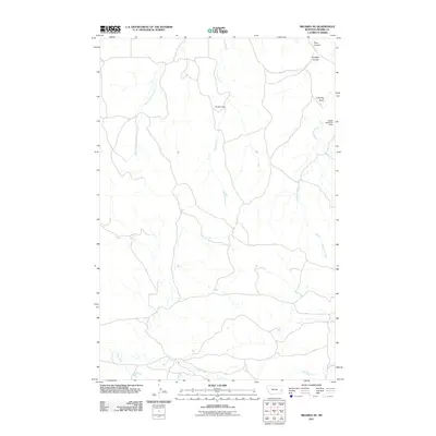
2011 Map of Mildred NE
USGS Topo · Published 2011About this map
Hay Creek and its tributary, the West Fork Hay Creek, define the central drainage of this Prairie County landscape, as documented in 2011. The map illustrates a network of rural water management and seasonal drainages characteristic of eastern Montana. Infrastructure is centered around local ranching and water conservation, most notably marked by the Buckley Dam near the center of the sheet and the Vogele Reservoir Dam further east. These water-retention features, alongside named landforms like Lambing Draw and Pumpkin Coulee, reflect the livestock-focused history of the region. The southern edge of the survey is bounded by the winding course of Pine Creek, while McNaney Creek carves a path through the eastern hills, showing the subtle but critical topographical shifts that dictate road and land use in this part of the state.
Find a feature on this map
9 named features on this map. Tap any name to fly to it.
Don’t see what you’re looking for? This feature index may not catch every label — zoom into the map to look around manually.
Map Details
Editions of this 2011 Mildred NE Map
This is the sole edition of this map. No revisions or reprints were ever made.
Other maps of this area

1953 · Miles City
USGS Topo · 1:250,000

1957 · Miles City
USGS Topo · 1:250,000

1958 · Miles City
USGS Topo · 1:250,000

1966 · Marsh SW
USGS Topo · 1:24,000

1981 · Mildred NE
USGS Topo · 1:24,000
1981 · Loony Hollow
USGS Topo · 1:24,000
1981 · Ismay North
USGS Topo · 1:24,000

1981 · Dorothy Draw
USGS Topo · 1:24,000

1981 · Ayer Spring
USGS Topo · 1:24,000
1981 · Mildred
USGS Topo · 1:24,000