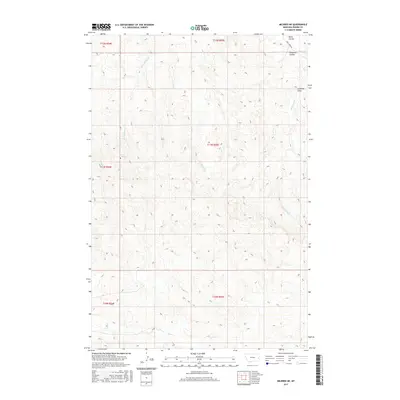
2017 Map of Mildred NE
USGS Topo · Published 2017About this map
McNaney Cr and Hay Cr carve a complex system of drainages through this corner of Prairie County, Montana, as documented in this 2017 U.S. Geological Survey topographic study. The landscape is defined by its seasonal watercourses and landform names that speak to its agricultural and ranching utility, such as Lambing Draw and Pumpkin Coulee. This high-plains terrain shows a sparse network of human markers, centered primarily on transportation routes like Cabin Creek Rd in the northeast. Small water sources like Shad Spring remain vital landmarks in this environment. The map provides a detailed view of the township and range boundaries, including t11n r55e and t12n r55e, which organize the vast acreage into the distinct sections used for modern land management and historical claims.
Find a feature on this map
15 named features on this map. Tap any name to fly to it.
Don’t see what you’re looking for? This feature index may not catch every label — zoom into the map to look around manually.
Map Details
Editions of this 2017 Mildred NE Map
This is the sole edition of this map. No revisions or reprints were ever made.
Other maps of this area

1953 · Miles City
USGS Topo · 1:250,000

1957 · Miles City
USGS Topo · 1:250,000

1958 · Miles City
USGS Topo · 1:250,000

1966 · Marsh SW
USGS Topo · 1:24,000

1981 · Mildred NE
USGS Topo · 1:24,000
1981 · Loony Hollow
USGS Topo · 1:24,000
1981 · Ismay North
USGS Topo · 1:24,000

1981 · Dorothy Draw
USGS Topo · 1:24,000

1981 · Ayer Spring
USGS Topo · 1:24,000
1981 · Mildred
USGS Topo · 1:24,000