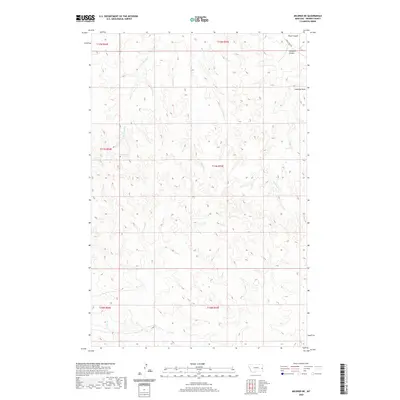
2020 Map of Mildred NE
USGS Topo · Published 2020About this map
Shad Spring provides a vital focal point in this high plains landscape of Prairie County, where the drainage patterns of several intermittent creeks define the topography. The northern portion of the map is marked by the distinct geographical cuts of Plum Coulee and Pumpkin Coulee, while Lambing Draw suggests a history of livestock management in this ranching country. Access to this remote area is primarily served by Cabin Creek Rd, which skirts the northeastern corner. The remainder of the terrain is a complex network of ephemeral waterways including W Fork Hay Cr, Hay Cr, and McNaney Cr. The township and range lines of the Public Land Survey System form the primary human-imposed structure over the natural draws and coulees of the eastern Montana plains.
Find a feature on this map
15 named features on this map. Tap any name to fly to it.
Don’t see what you’re looking for? This feature index may not catch every label — zoom into the map to look around manually.
Map Details
Editions of this 2020 Mildred NE Map
This is the sole edition of this map. No revisions or reprints were ever made.
Other maps of this area

1953 · Miles City
USGS Topo · 1:250,000

1957 · Miles City
USGS Topo · 1:250,000

1958 · Miles City
USGS Topo · 1:250,000

1966 · Marsh SW
USGS Topo · 1:24,000

1981 · Mildred NE
USGS Topo · 1:24,000
1981 · Loony Hollow
USGS Topo · 1:24,000
1981 · Ismay North
USGS Topo · 1:24,000

1981 · Dorothy Draw
USGS Topo · 1:24,000

1981 · Ayer Spring
USGS Topo · 1:24,000
1981 · Mildred
USGS Topo · 1:24,000