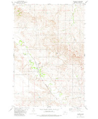
1981 Map of Mildred
USGS Topo · Published 1981About this map
Mildred serves as the central hub of this eastern Montana landscape, situated at the intersection of a significant regional waterway and a major transport artery. The winding course of O Fallon Creek dominates the valley floor, paralleled by the tracks of the Chicago Milwaukee St Paul and Pacific railroad. This alignment reflects the historical reliance of Prairie County ranching and farming communities on rail access for commerce and connectivity during the late twentieth century. Scattered water sources, including Spring Creek, Pine Creek, and several Flowing Wells, highlight the essential infrastructure required to support life and livestock in this semiarid region. Smaller features such as a local Cem and Marshall Dam provide specific touchpoints for genealogical research and land-use studies, while various drill holes across the terrain point to mineral exploration efforts of the era.
Find a feature on this map
12 named features on this map. Tap any name to fly to it.
Don’t see what you’re looking for? This feature index may not catch every label — zoom into the map to look around manually.
Map Details
Editions of this 1981 Mildred Map
This is the sole edition of this map. No revisions or reprints were ever made.
Other maps of this area

1953 · Miles City
USGS Topo · 1:250,000

1957 · Miles City
USGS Topo · 1:250,000

1958 · Miles City
USGS Topo · 1:250,000

1966 · Fallon
USGS Topo · 1:24,000

1966 · Marsh SW
USGS Topo · 1:24,000

1969 · Little Whitney Creek
USGS Topo · 1:24,000

1969 · Flat Top Butte NE
USGS Topo · 1:24,000

1980 · Terry
USGS Topo · 1:100,000

1981 · Mildred NE
USGS Topo · 1:24,000
1981 · Loony Hollow
USGS Topo · 1:24,000