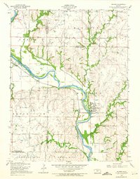
1955 Map of Milford
USGS Topo · Published 1974About this map
The Republican River meanders through the heart of this mid-century Kansas landscape, defining the topography across the borders of Geary, Riley, and Clay counties. This survey, based on 1950s field checks, reveals the township of Milford as a critical junction for the Union Pacific railroad, centered around the Milford Station. The cultural layer is particularly dense with rural institutions, including the Myersdale School, Zoar School, and Hillside Church, which served the surrounding farming townships of Madison and Grant.
Find a feature on this map
29 named features on this map. Tap any name to fly to it.
Don’t see what you’re looking for? This feature index may not catch every label — zoom into the map to look around manually.
Map Details
Editions of this 1955 Milford Map
3 editions found

Other maps of this area

1886 · Junction City
USGS Topo · 1:125,000

1889 · Junction City
USGS Topo · 1:125,000

1891 · Clay Center
USGS Topo · 1:125,000

1894 · Junction City
USGS Topo · 1:125,000

1947 · Fort Riley
USGS Topo · 1:62,500

1950 · Junction City
USGS Topo · 1:24,000

1950 · Alida
USGS Topo · 1:24,000

1951 · Wind Creek
USGS Topo · 1:24,000

1951 · Milford
USGS Topo · 1:24,000

1955 · Fort Riley NE
USGS Topo · 1:24,000