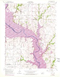
1955 Map of Milford
USGS Topo · Published 1978About this map
Milford Lake dominates the central landscape of this mid-century survey, its expansive purple-shaded revisions reflecting the planned inundation of the Republican River valley. The town of Milford sits on the eastern shore, a focal point for local history featuring a Water Tank and a Trailer Park. To the north, the boundary of the Fort Riley Military Reservation marks a transition from civilian farmstead terrain to military-controlled land. This sheet provides a detailed look at rural Kansas life before and during major water management changes, preserving the locations of legacy landmarks such as the Indian Grave Monument and Zoar School. The terrain transitions from the elevations of Fragrant Hill and Smoky Hill in the south toward the creek-fed lowlands of Madison Creek and Farnum Creek in the north and east.
Find a feature on this map
26 named features on this map. Tap any name to fly to it.
Don’t see what you’re looking for? This feature index may not catch every label — zoom into the map to look around manually.
Map Details
Editions of this 1955 Milford Map
3 editions found

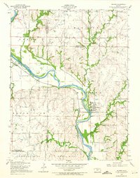
Other maps of this area

1886 · Junction City
USGS Topo · 1:125,000

1889 · Junction City
USGS Topo · 1:125,000

1891 · Clay Center
USGS Topo · 1:125,000

1894 · Junction City
USGS Topo · 1:125,000

1947 · Fort Riley
USGS Topo · 1:62,500

1950 · Junction City
USGS Topo · 1:24,000

1950 · Alida
USGS Topo · 1:24,000

1951 · Wind Creek
USGS Topo · 1:24,000

1951 · Milford
USGS Topo · 1:24,000

1955 · Fort Riley NE
USGS Topo · 1:24,000