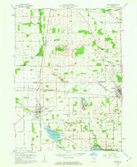
1962 Map of Milford
USGS Topo · Published 1963About this map
Turkey Creek and Solomon Creek dominate this northern Indiana landscape as it appeared in the early 1960s, winding through the townships of Jackson, Benton, and Van Buren. The intersection of the New York Central and Baltimore and Ohio railroads at Milford Junction underscores the region's historic reliance on rail transport for agricultural distribution. To the south, the village of Milford serves as a primary hub, while the resort character of the area begins to emerge around Wabee Lake and Dewart Lake.
Find a feature on this map
39 named features on this map. Tap any name to fly to it.
Don’t see what you’re looking for? This feature index may not catch every label — zoom into the map to look around manually.
Map Details
Editions of this 1962 Milford Map
3 editions found
Other maps of this area

1950 · Leesburg
USGS Topo · 1:24,000

1950 · North Webster
USGS Topo · 1:24,000

1951 · Milford
USGS Topo · 1:24,000

1951 · Wawasee
USGS Topo · 1:24,000

1953 · Fort Wayne
USGS Topo · 1:250,000

1956 · Fort Wayne
USGS Topo · 1:250,000

1958 · Nappanee East
USGS Topo · 1:24,000

1959 · Atwood
USGS Topo · 1:24,000

1959 · Millersburg
USGS Topo · 1:24,000

1959 · Goshen
USGS Topo · 1:24,000