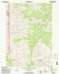
1991 Map of Milk Creek
USGS Topo · Published 1997About this map
Shoshone National Forest defines the western edge of this high-elevation landscape, where the drainage systems of Grass Creek and Milk Creek carve through the foothills of Hot Springs County. The 1991 field revision captures a rugged pocket of Wyoming characterized by dramatic topographical markers such as Squaw Teat Butte, Sugar Loaf Mountain, and the curiously named rock formation known as The Holy City.
Find a feature on this map
29 named features on this map. Tap any name to fly to it.
Don’t see what you’re looking for? This feature index may not catch every label — zoom into the map to look around manually.
Map Details
Editions of this 1991 Milk Creek Map
This is the sole edition of this map. No revisions or reprints were ever made.
Other maps of this area

1904 · Kirwin
USGS Topo · 1:125,000

1906 · Kirwin
USGS Topo · 1:125,000

1955 · Thermopolis
USGS Topo · 1:250,000

1956 · Milk Creek
USGS Topo · 1:24,000

1956 · Twentyone Creek
USGS Topo · 1:24,000

1956 · Soapy Dale Peak
USGS Topo · 1:24,000

1956 · Adam Weiss Peak
USGS Topo · 1:24,000

1958 · Thermopolis
USGS Topo · 1:250,000

1962 · Thermopolis
USGS Topo · 1:250,000
1965 · Eagle Nest Ranch
USGS Topo · 1:24,000