
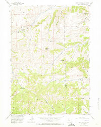
1956 Map of Soapy Dale Peak
USGS Topo · Published 1958About this map
Gooseberry Creek and its complex network of draws and canyons define this high-elevation landscape along the boundary of Park Co Hot Springs Co. Published in the mid-1950s as part of the Missouri River Basin development program, this survey documents a transition from the structured grazing lands of the Shoshone National Forest to the private holdings found at Dollar Ranch and Buckles Ranch. The terrain is marked by significant vertical relief, characterized by prominent landmarks like Red Cliff, Wall Rock, and the high point of Soapy Dale Peak.
Find a feature on this map
27 named features on this map. Tap any name to fly to it.
Don’t see what you’re looking for? This feature index may not catch every label — zoom into the map to look around manually.
Map Details
Editions of this 1956 Soapy Dale Peak Map
2 editions found
Other maps of this area

1904 · Kirwin
USGS Topo · 1:125,000

1906 · Kirwin
USGS Topo · 1:125,000

1911 · Meeteetse
USGS Topo · 1:62,500

1913 · Meeteetse
USGS Topo · 1:62,500

1955 · Cody
USGS Topo · 1:250,000

1955 · Thermopolis
USGS Topo · 1:250,000

1956 · Milk Creek
USGS Topo · 1:24,000

1956 · Twentyone Creek
USGS Topo · 1:24,000

1956 · Adam Weiss Peak
USGS Topo · 1:24,000

1957 · Sunshine Reservoir
USGS Topo · 1:62,500