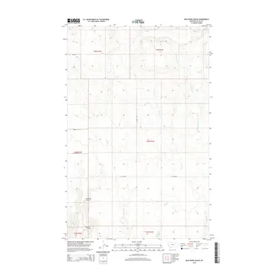
2014 Map of Milk River Coulee
USGS Topo · Published 2014About this map
The high plains of Valley County north of the Missouri River are defined here by the intricate drainage systems of Kintyre Cr and Charley Cr. This landscape is primarily shaped by the erosional patterns of these watercourses, including the W Fork Charley Cr, which carve through the Montana terrain. The map reflects a classic western section-line grid, where human development is almost entirely limited to rural thoroughfares such as Bauer Rd, Wagner Rd, and Ivy Couiee Rd. These roads provide the primary access to the large agricultural or grazing tracts that occupy the expansive townships, spanning from T29N down to T27N. The absence of concentrated settlements emphasizes the remote, ranching character of this region during the early twenty-first century.
Find a feature on this map
12 named features on this map. Tap any name to fly to it.
Don’t see what you’re looking for? This feature index may not catch every label — zoom into the map to look around manually.
Map Details
Editions of this 2014 Milk River Coulee Map
This is the sole edition of this map. No revisions or reprints were ever made.
Other maps of this area

1914 · Nashua
USGS Topo · 1:62,500

1915 · Frazer
USGS Topo · 1:62,500

1915 · Spring Creek
USGS Topo · 1:62,500

1916 · Nashua
USGS Topo · 1:62,500

1918 · Porcupine Valley
USGS Topo · 1:62,500

1954 · Glasgow
USGS Topo · 1:250,000

1957 · Glasgow
USGS Topo · 1:250,000

1958 · Glasgow
USGS Topo · 1:250,000
1972 · Frazer
USGS Topo · 1:24,000
1972 · Dubbe Reservoir
USGS Topo · 1:24,000