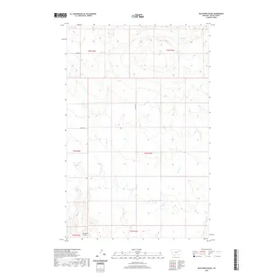
2020 Map of Milk River Coulee
USGS Topo · Published 2020About this map
Milk River Coulee defines the southern reach of this landscape in Valley County, where the dry drainage patterns typical of the Montana plains meet the high prairie. The northern portion of the terrain is marked by Mud Lake, a significant water feature in a region defined by seasonal creek beds. The drainage network is particularly intricate here, with Charley Cr, its W Fork Charley Cr, and Kintyre Cr carving winding paths through the sections. These watercourses reflect the hydrologic character of the eastern Montana grasslands, where intermittent flows shape the coulee topography. Human infrastructure is represented by rural connectors like Bauer Rd and Wagner Rd, which follow the rigid section lines of the Public Land Survey System, a contrast to the meandering natural paths of the local creeks.
Find a feature on this map
13 named features on this map. Tap any name to fly to it.
Don’t see what you’re looking for? This feature index may not catch every label — zoom into the map to look around manually.
Map Details
Editions of this 2020 Milk River Coulee Map
This is the sole edition of this map. No revisions or reprints were ever made.
Other maps of this area

1914 · Nashua
USGS Topo · 1:62,500

1915 · Frazer
USGS Topo · 1:62,500

1915 · Spring Creek
USGS Topo · 1:62,500

1916 · Nashua
USGS Topo · 1:62,500

1918 · Porcupine Valley
USGS Topo · 1:62,500

1954 · Glasgow
USGS Topo · 1:250,000

1957 · Glasgow
USGS Topo · 1:250,000

1958 · Glasgow
USGS Topo · 1:250,000
1972 · Frazer
USGS Topo · 1:24,000
1972 · Dubbe Reservoir
USGS Topo · 1:24,000