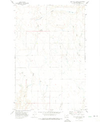
1972 Map of Milk River Coulee
USGS Topo · Published 1975About this map
The Milk River carves a winding path through this portion of Valley County, Montana, defining a landscape of complex drainage systems and semi-arid terrain within the Fort Peck Indian Reservation. This 1972 field-checked survey highlights the dramatic relief of the Milk River Coulee and the intricate network of seasonal waterways including Kintyre Creek and Charley Creek. The map documents a sparsely populated ranching environment where water sources are the primary landmarks.
Find a feature on this map
9 named features on this map. Tap any name to fly to it.
Don’t see what you’re looking for? This feature index may not catch every label — zoom into the map to look around manually.
Map Details
Editions of this 1972 Milk River Coulee Map
This is the sole edition of this map. No revisions or reprints were ever made.
Other maps of this area

1914 · Nashua
USGS Topo · 1:62,500

1915 · Frazer
USGS Topo · 1:62,500

1915 · Spring Creek
USGS Topo · 1:62,500

1916 · Nashua
USGS Topo · 1:62,500

1918 · Porcupine Valley
USGS Topo · 1:62,500

1954 · Glasgow
USGS Topo · 1:250,000

1957 · Glasgow
USGS Topo · 1:250,000

1958 · Glasgow
USGS Topo · 1:250,000
1972 · Frazer
USGS Topo · 1:24,000
1972 · Dubbe Reservoir
USGS Topo · 1:24,000