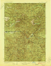
1929 Map of Mill City
USGS Topo · Published 1929About this map
The North Fork Santiam River serves as the industrial and transit spine of this 1920s landscape, carrying the Southern Pacific railroad line through the timber-rich Cascades. Mill City and Gates anchor the western edge of the corridor, while the remote settlement of Quartzville sits deep within the southern forest, a relic of the region's mining heritage. The map documents an era of active extraction and forest management, evidenced by the cluster of Ogle Mtn Mines and the Silver King Mine tucked into the steep drainages. These operations, alongside federal outposts like the Bagby Hot Springs Ranger Sta and Elk Lake Ranger Sta, show a wilderness transitioning into a managed resource landscape. Along the river, smaller stops like Niagara and Detroit mark the path of the railroad before it climbs toward the high peaks of the Santiam National Forest.
Find a feature on this map
89 named features on this map. Tap any name to fly to it.
Don’t see what you’re looking for? This feature index may not catch every label — zoom into the map to look around manually.
Map Details
Editions of this 1929 Mill City Map
4 editions found
Other maps of this area

1916 · Estacada
USGS Topo · 1:125,000

1924 · Mount Hood
USGS Topo · 1:125,000

1927 · Mount Hood
USGS Topo · 1:125,000

1927 · Mt. Jefferson
USGS Topo · 1:125,000

1929 · Mill City
USGS Topo · 1:125,000

1929 · Three Sisters
USGS Topo · 1:125,000

1930 · Mt. Jefferson
USGS Topo · 1:125,000

1932 · Three Sisters
USGS Topo · 1:125,000

1934 · Mc Kenzie Bridge
USGS Topo · 1:96,000

1939 · Molalla
USGS Topo · 1:62,500