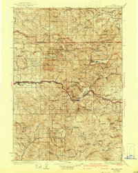
1929 Map of Mill City
USGS Topo · Published 1941About this map
Mill City and the Southern Pacific railroad corridor serve as the industrial anchors for this timber and mining region during the mid-1920s. Following the Little North Santiam River and its tributaries, the map reveals a landscape defined by resource extraction, featuring numerous active sites such as the Silver King Mine, Black Eagle Mine, and Crown Mine. The settlement of Quartzville sits deep within the southern peaks, connected by a network of trails and routes usually traveled that bridge the gap between high-altitude lookouts like Table Rock Lookout and the river valley floor.
Find a feature on this map
150 named features on this map. Tap any name to fly to it.
Don’t see what you’re looking for? This feature index may not catch every label — zoom into the map to look around manually.
Map Details
Editions of this 1929 Mill City Map
4 editions found
Other maps of this area

1916 · Estacada
USGS Topo · 1:125,000

1924 · Mount Hood
USGS Topo · 1:125,000

1927 · Mount Hood
USGS Topo · 1:125,000

1927 · Mt. Jefferson
USGS Topo · 1:125,000

1929 · Mill City
USGS Topo · 1:125,000

1929 · Three Sisters
USGS Topo · 1:125,000

1930 · Mt. Jefferson
USGS Topo · 1:125,000

1932 · Three Sisters
USGS Topo · 1:125,000

1934 · Mc Kenzie Bridge
USGS Topo · 1:96,000

1939 · Molalla
USGS Topo · 1:62,500