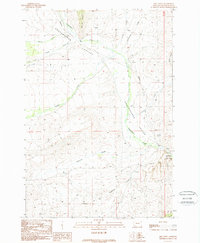
1988 Map of Mill Point
USGS Topo · Published 1989About this map
Grasshopper Valley dominates this landscape in Beaverhead County, Montana, providing a corridor for Grasshopper Creek as it meanders toward the southeast corner of the map. The area serves as a focal point for late-century preservation at Bannack State Park, where campers utilize the established Campgrounds. Evidence of local industry and geology appears in the northern reaches, where a Claypit and several Prospects suggest historical mineral exploration near the heights of Mill Point. The settlement of Hayes is positioned along the creek, while the Bannack Cem provides a critical point of interest for those tracing lineage in this part of Montana. Tributaries such as Buffalo Creek, Cottonwood Creek, and Sagebrush Creek create a complex drainage system across the basin, supporting the grazing and ranching patterns common to this high valley.
Find a feature on this map
22 named features on this map. Tap any name to fly to it.
Don’t see what you’re looking for? This feature index may not catch every label — zoom into the map to look around manually.
Map Details
Editions of this 1988 Mill Point Map
This is the sole edition of this map. No revisions or reprints were ever made.
Other maps of this area

1893 · Dillon
USGS Topo · 1:250,000

1952 · Bannack
USGS Topo · 1:24,000

1952 · Eli Spring
USGS Topo · 1:24,000

1952 · Ermont
USGS Topo · 1:24,000

1955 · Dillon
USGS Topo · 1:250,000

1957 · Dillon
USGS Topo · 1:250,000

1958 · Dillon
USGS Topo · 1:250,000

1959 · Polaris
USGS Topo · 1:62,500

1959 · Grant
USGS Topo · 1:62,500

1962 · Dillon
USGS Topo · 1:250,000