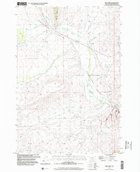
1997 Map of Mill Point
USGS Topo · Published 2002About this map
Grasshopper Valley cuts a prominent diagonal through this Montana landscape, following the course of Grasshopper Creek as it winds past the historic grounds of Bannack State Park. This region, documented during a late-1990s revision, shows a rugged terrain defined by significant mining and industrial activity, evidenced by Tailings, multiple Prospects, and a Claypit near Dyce Creek. Local history and genealogy are centered on the Bannack Cem and nearby Campgrounds, situated where the valley narrows. The hydrology of the area is complex, with numerous tributaries such as Cottonwood Creek, Taylor Creek, and Sagebrush Creek feeding the main drainage. To the north, Mill Point stands as a distinctive landmark above the confluence of Swamp Creek and Hayes Creek, illustrating the transition from open valley floor to the more complex topography of the Beaverhead region.
Find a feature on this map
24 named features on this map. Tap any name to fly to it.
Don’t see what you’re looking for? This feature index may not catch every label — zoom into the map to look around manually.
Map Details
Editions of this 1997 Mill Point Map
This is the sole edition of this map. No revisions or reprints were ever made.
Other maps of this area

1893 · Dillon
USGS Topo · 1:250,000

1952 · Bannack
USGS Topo · 1:24,000

1952 · Eli Spring
USGS Topo · 1:24,000

1952 · Ermont
USGS Topo · 1:24,000

1955 · Dillon
USGS Topo · 1:250,000

1957 · Dillon
USGS Topo · 1:250,000

1958 · Dillon
USGS Topo · 1:250,000

1959 · Polaris
USGS Topo · 1:62,500

1959 · Grant
USGS Topo · 1:62,500

1962 · Dillon
USGS Topo · 1:250,000