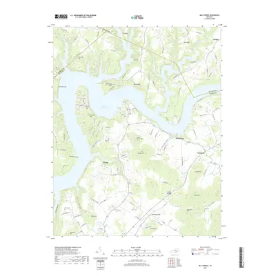
2019 Map of Mill Springs
USGS Topo · Published 2019About this map
Lake Cumberland dominates this 2019 survey, its irregular fingers reaching deep into the forested hills of Wayne and Pulaski Counties. The map covers several small settlements including Mill Springs, Touristville, and Steubenville, showing the modern road network built around the topography of the Cumberland River basin. For genealogists and local historians, numerous family-named burial sites are mapped, such as Sloan Cem, Dodson Cem, and Norman Cem, providing a record of long-established residents in the area. The terrain is marked by distinctive named high points and ridges, from the Gap of the Ridge and Hoozer Hill in the southeast to Shinbone Cliff overlooking the water in the northwest. This modern product integrates national datasets to show current land use, where residential development like the Lighthouse Dr neighborhood sits alongside historical locations like the Simpson Spring and the steep hollows typical of this Kentucky region.
Find a feature on this map
117 named features on this map. Tap any name to fly to it.
Don’t see what you’re looking for? This feature index may not catch every label — zoom into the map to look around manually.
Map Details
Editions of this 2019 Mill Springs Map
This is the sole edition of this map. No revisions or reprints were ever made.
Other maps of this area

1911 · Monticello
USGS Topo · 1:62,500

1914 · Monticello
USGS Topo · 1:62,500

1932 · Burnside
USGS Topo · 1:62,500

1935 · Somerset
USGS Topo · 1:62,500

1953 · Frazer
USGS Topo · 1:24,000

1953 · Parnell
USGS Topo · 1:24,000

1953 · Monticello
USGS Topo · 1:24,000

1953 · Mill Springs
USGS Topo · 1:24,000

1954 · Jabez
USGS Topo · 1:24,000

1954 · Coopersville
USGS Topo · 1:24,000