
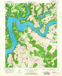
1953 Map of Mill Springs
USGS Topo · Published 1955About this map
Lake Cumberland dominates the northern landscape of this 1953 survey, winding through the rugged border of Pulaski and Wayne Counties. The map documents a critical era of transition as the impounded waters of the Cumberland River reshaped local geography, creating prominent features like Cumberland Point and flooding the lower reaches of Faubush Creek. Inland, the settlement of Mill Springs sits near the site of the Mill Springs Battlefield, a key Civil War location, and the adjacent Mill Springs State Park. The southern portion of the quadrangle is defined by a series of prominent knobs and hills, including Hannah Hill and Boston Hill, where small communities like Touristville and Steubenville are connected by local roads and dotted with rural landmarks such as Lockett Chapel Ch and several one-room schools like Carr Sch.
Find a feature on this map
51 named features on this map. Tap any name to fly to it.
Don’t see what you’re looking for? This feature index may not catch every label — zoom into the map to look around manually.
Map Details
Editions of this 1953 Mill Springs Map
2 editions found
Other maps of this area

1911 · Monticello
USGS Topo · 1:62,500

1914 · Monticello
USGS Topo · 1:62,500

1932 · Burnside
USGS Topo · 1:62,500

1935 · Somerset
USGS Topo · 1:62,500

1953 · Frazer
USGS Topo · 1:24,000

1953 · Parnell
USGS Topo · 1:24,000

1953 · Monticello
USGS Topo · 1:24,000

1954 · Jabez
USGS Topo · 1:24,000

1954 · Coopersville
USGS Topo · 1:24,000

1954 · Delmer
USGS Topo · 1:24,000