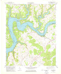
1978 Map of Mill Springs
USGS Topo · Published 1978About this map
Lake Cumberland dominates the northern landscape of this Wayne County survey, its sprawling waters filling the former valley of the Cumberland River. The map documents the mid-century transformation of the area into a major recreational hub, featuring the Conley Bottom Dock and the Cumberland Point Recreational Area. Despite these modern developments, the land retains its deep historical identity, anchored by the Mill Springs Battlefield and Mill Springs State Park.
Find a feature on this map
63 named features on this map. Tap any name to fly to it.
Don’t see what you’re looking for? This feature index may not catch every label — zoom into the map to look around manually.
Map Details
Editions of this 1978 Mill Springs Map
This is the sole edition of this map. No revisions or reprints were ever made.
Other maps of this area

1911 · Monticello
USGS Topo · 1:62,500

1914 · Monticello
USGS Topo · 1:62,500

1932 · Burnside
USGS Topo · 1:62,500

1935 · Somerset
USGS Topo · 1:62,500

1953 · Frazer
USGS Topo · 1:24,000

1953 · Parnell
USGS Topo · 1:24,000

1953 · Monticello
USGS Topo · 1:24,000

1953 · Mill Springs
USGS Topo · 1:24,000

1954 · Jabez
USGS Topo · 1:24,000

1954 · Coopersville
USGS Topo · 1:24,000