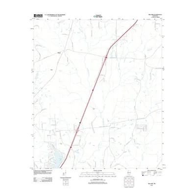
2012 Map of Millard
USGS Topo · Published 2012About this map
Millard and Tyler serve as the primary hubs in this rural Pearl River County landscape, defined by a complex network of waterways and timberland. The watershed of the E Hobolochitto Cr dominates the central terrain, fed by numerous tributaries including Jumpoff Cr, Juniper Cr, and Moran Cr. In the southwestern portion of the map, the residential development around Anchor Lake stands out against the surrounding forest, with street names like Treasure Pt and Buccaneer Cir marking the lakeside community. For those tracing family histories, the map identifies localized landmarks such as Martin Cem and Spiers Cem, alongside many family-named roads like Ben Sones Rd and Lamar Smith Rd that hint at the generational landholdings in this part of Mississippi.
Find a feature on this map
75 named features on this map. Tap any name to fly to it.
Don’t see what you’re looking for? This feature index may not catch every label — zoom into the map to look around manually.
Map Details
Editions of this 2012 Millard Map
This is the sole edition of this map. No revisions or reprints were ever made.
Other maps of this area

1953 · Mobile
USGS Topo · 1:250,000

1955 · Savannah
USGS Topo · 1:62,500

1957 · Mobile
USGS Topo · 1:250,000

1958 · Carnes
USGS Topo · 1:62,500

1958 · Picayune
USGS Topo · 1:62,500

1959 · Poplarville
USGS Topo · 1:62,500

1960 · Mobile
USGS Topo · 1:250,000

1963 · Mobile
USGS Topo · 1:250,000

1965 · Mobile
USGS Topo · 1:250,000
1982 · Necaise
USGS Topo · 1:24,000