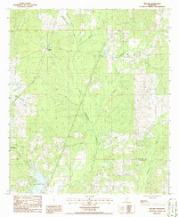
1986 Map of Millard
USGS Topo · Published 1986About this map
The Southern railroad line serves as a central spine through this portion of Mississippi, connecting the small communities of Millard and Tyler. This mid-1980s survey illustrates a landscape dominated by the winding drainage networks of Hobolochitto Creek and its many tributaries, including Cypress Creek, Jumpoff Creek, and Juniper Creek. In the southwest, Anchor Lake provides a notable water feature with a designated Rest Area nearby, suggesting a focus on local recreation amidst the timbered terrain. The industrial footprint of the era is visible through a Gravel Pit located near the Pearl River Co Hancock Co boundary. The presence of Fish Ponds further south indicates the varied use of the region's abundant water resources. This map offers a clear look at the rural infrastructure and natural hydrology of the area before modern expansion altered the character of these small rail-side settlements.
Find a feature on this map
16 named features on this map. Tap any name to fly to it.
Don’t see what you’re looking for? This feature index may not catch every label — zoom into the map to look around manually.
Map Details
Editions of this 1986 Millard Map
This is the sole edition of this map. No revisions or reprints were ever made.
Other maps of this area

1953 · Mobile
USGS Topo · 1:250,000

1955 · Savannah
USGS Topo · 1:62,500

1957 · Mobile
USGS Topo · 1:250,000

1958 · Carnes
USGS Topo · 1:62,500

1958 · Picayune
USGS Topo · 1:62,500

1959 · Poplarville
USGS Topo · 1:62,500

1960 · Mobile
USGS Topo · 1:250,000

1963 · Mobile
USGS Topo · 1:250,000

1965 · Mobile
USGS Topo · 1:250,000
1982 · Necaise
USGS Topo · 1:24,000