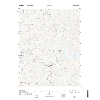
2019 Map of Millard
USGS Topo · Published 2019About this map
Levisa Fork and Russell Fork converge in this eastern Kentucky landscape, anchoring a series of communities that follow the narrow valley floors. The convergence at Levisa Junction and the nearby settlement of Millard reflect the traditional transportation corridor through the Cumberland Plateau. Steep ridges like Stratton Knob and Town Mtn separate the hollows, where local history is preserved in family and community burial grounds including Annie E Young Cem and Collins Cem. The creation of Fishtrap Lake significantly altered the eastern drainage patterns, while smaller bodies of water like Chloe Lake dot the western hills. This geography demonstrates the typical Appalachian settlement pattern, with residences and infrastructure tightly clustered in names like Garden Village and Shelbiana along the arterial Shelby Creek.
Find a feature on this map
122 named features on this map. Tap any name to fly to it.
Don’t see what you’re looking for? This feature index may not catch every label — zoom into the map to look around manually.
Map Details
Editions of this 2019 Millard Map
This is the sole edition of this map. No revisions or reprints were ever made.
Other maps of this area

1886 · Prestonsburg
USGS Topo · 1:125,000

1886 · Grundy
USGS Topo · 1:125,000

1887 · Warfield
USGS Topo · 1:125,000

1890 · Whitesburg
USGS Topo · 1:125,000

1890 · Grundy
USGS Topo · 1:125,000

1891 · Warfield
USGS Topo · 1:125,000

1892 · Grundy
USGS Topo · 1:125,000

1892 · Whitesburg
USGS Topo · 1:125,000

1892 · Prestonsburg
USGS Topo · 1:125,000

1914 · Laynesville
USGS Topo · 1:48,000