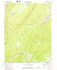
1969 Map of Millboro
USGS Topo · Published 1979About this map
Millboro Springs and the village of Millboro anchor this survey of the mountainous border between Bath and Rockbridge counties. The landscape is defined by the steep ridges of Mill Mountain and Bratton Mountain, where the Chesapeake and Ohio railroad navigates the difficult terrain through the Millboro Tunnel and Lick Run Tunnel. These engineering feats highlight the importance of the rail corridor in connecting the rural communities of the western highlands.
Find a feature on this map
43 named features on this map. Tap any name to fly to it.
Don’t see what you’re looking for? This feature index may not catch every label — zoom into the map to look around manually.
Map Details
Editions of this 1969 Millboro Map
3 editions found
Other maps of this area

1894 · Staunton
USGS Topo · 1:125,000

1894 · Natural Bridge
USGS Topo · 1:125,000

1894 · Lexington
USGS Topo · 1:125,000

1901 · Monterey
USGS Topo · 1:125,000

1932 · Lexington
USGS Topo · 1:48,000

1937 · Lexington
USGS Topo · 1:62,500

1943 · Craigsville
USGS Topo · 1:62,500

1945 · Craigsville
USGS Topo · 1:62,500

1946 · Millboro
USGS Topo · 1:62,500

1946 · Williamsville
USGS Topo · 1:62,500