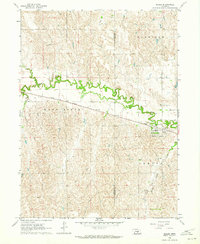
1962 Map of Miller
USGS Topo · Published 1964About this map
The Union Pacific railroad cuts a straight line through the central Platte Valley landscape, anchoring the settlement of Miller as a regional transport hub in the early 1960s. This survey highlights the intersection of transportation and topography, where the village is positioned just north of Cherry Valley Creek and south of the winding Wood River. The map provides a clear look at the township divisions of Harrison, Wood River, and Armada, reflecting the organized land management of rural Buffalo County.
Find a feature on this map
24 named features on this map. Tap any name to fly to it.
Don’t see what you’re looking for? This feature index may not catch every label — zoom into the map to look around manually.
Map Details
Editions of this 1962 Miller Map
This is the sole edition of this map. No revisions or reprints were ever made.
Other maps of this area

1896 · Lexington
USGS Topo · 1:125,000

1896 · Kearney
USGS Topo · 1:125,000

1899 · Lexington
USGS Topo · 1:125,000

1951 · Mason City SW
USGS Topo · 1:24,000

1951 · Eddyville
USGS Topo · 1:24,000

1951 · Mason City SE
USGS Topo · 1:24,000

1955 · Broken Bow
USGS Topo · 1:250,000

1955 · Grand Island
USGS Topo · 1:250,000

1956 · Broken Bow
USGS Topo · 1:250,000

1957 · Grand Island
USGS Topo · 1:250,000