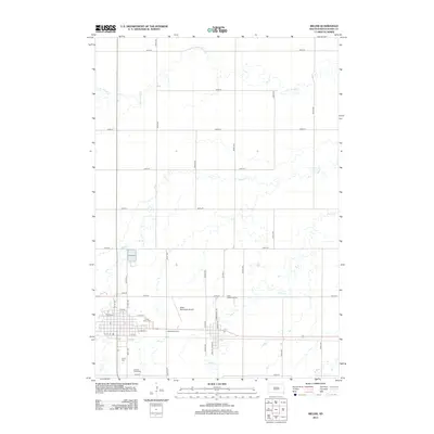
2012 Map of Miller
USGS Topo · Published 2012About this map
Miller serves as the central hub of this Hand County landscape, where the town's grid is defined by streets like W 1st St and Commercial St. The surrounding countryside is primarily shaped by the meandering courses of Turtle Cr and Little Turtle Cr, illustrating the drainage patterns of the South Dakota prairie. Local history and community life are grounded in landmarks such as the Saint Anns Cem and G A R Cem, alongside the Saint Lawrence Cem situated to the east. Transportation and recreation are represented by the Miller Municipal Airport, the nostalgic Midway Drive-In, and the Central Speedway, showing how the town expanded its footprint into the rural sections while maintaining its core agricultural and community identity.
Find a feature on this map
41 named features on this map. Tap any name to fly to it.
Don’t see what you’re looking for? This feature index may not catch every label — zoom into the map to look around manually.
Map Details
Editions of this 2012 Miller Map
This is the sole edition of this map. No revisions or reprints were ever made.
Other maps of this area

1899 · Redfield
USGS Topo · 1:125,000

1950 · Ree Heights SE
USGS Topo · 1:24,000

1950 · Vayland
USGS Topo · 1:24,000

1950 · Vayland NW
USGS Topo · 1:24,000

1951 · Ree Heights NE
USGS Topo · 1:24,000

1953 · Huron
USGS Topo · 1:250,000

1954 · Huron
USGS Topo · 1:250,000

1966 · Burdette
USGS Topo · 1:24,000

1967 · Miller
USGS Topo · 1:24,000
1967 · Miller SE
USGS Topo · 1:24,000