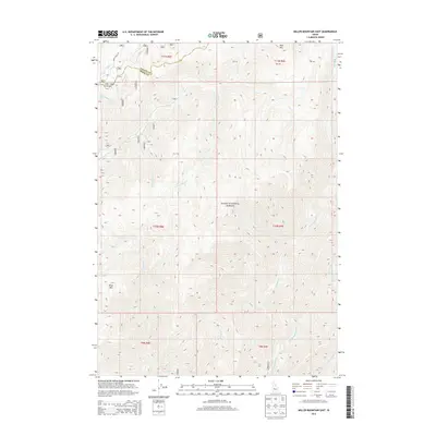
2013 Map of Miller Mountain East
USGS Topo · Published 2013About this map
The Boise National Forest encompasses this high-elevation terrain where the divide between Valley and Boise counties is defined by the peaks of the Salmon River Mountains. In the early 21st century, this landscape remains dominated by a dense network of drainages including Bear Valley Creek and Eightmile Creek, which feed into larger river systems beyond the map's edge. Significant elevations are marked by Miller Mountain in the southwest and Red Mountain in the northeast corner. The primary transit route through this wilderness is the Bear Valley Road, which skirts the northwestern quadrant near Clear Creek Summit. The map illustrates the headwaters of numerous streams such as Fivemile Creek and Kettle Creek, providing a detailed look at the complex hydrology and topographic relief that characterizes this protected forest region.
Find a feature on this map
17 named features on this map. Tap any name to fly to it.
Don’t see what you’re looking for? This feature index may not catch every label — zoom into the map to look around manually.
Map Details
Editions of this 2013 Miller Mountain East Map
This is the sole edition of this map. No revisions or reprints were ever made.
Other maps of this area

1891 · Bear Valley
USGS Topo · 1:125,000

1893 · Bear Valley
USGS Topo · 1:125,000

1909 · Garden Valley
USGS Topo · 1:125,000

1953 · Deadwood Reservoir
USGS Topo · 1:62,500

1957 · Challis
USGS Topo · 1:250,000

1960 · Challis
USGS Topo · 1:250,000

1963 · Challis
USGS Topo · 1:250,000

1972 · Bull Trout Point
USGS Topo · 1:24,000

1972 · Cache Creek
USGS Topo · 1:24,000
1972 · Tyee Mountain
USGS Topo · 1:24,000