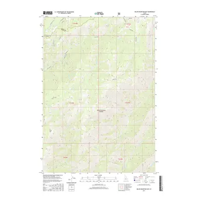
2017 Map of Miller Mountain East
USGS Topo · Published 2017About this map
The Boise National Forest defines this high-elevation landscape along the boundary of Valley and Boise Counties. This 2017 survey details a network of drainage systems feeding into Bear Valley Cr and Clear Creek, which dominate the northern half of the quadrangle. The terrain is marked by significant features like Kirkham Ridge and the distinct peaks of Miller Mtn and Red Mountain. Access into this backcountry is primary via the Lowman-Bear Valley road and Eastside Road, alongside various forest spurs and trails like Long Creek W 6. The map provides a clear view of the complex hydrology of the area, including the upper reaches of Eightmile Cr and Fivemile Cr, which flow through the southern sections. This modern topographic study is essential for understanding the contemporary management and physical geography of this part of Idaho's protected forest lands.
Find a feature on this map
33 named features on this map. Tap any name to fly to it.
Don’t see what you’re looking for? This feature index may not catch every label — zoom into the map to look around manually.
Map Details
Editions of this 2017 Miller Mountain East Map
This is the sole edition of this map. No revisions or reprints were ever made.
Other maps of this area

1891 · Bear Valley
USGS Topo · 1:125,000

1893 · Bear Valley
USGS Topo · 1:125,000

1909 · Garden Valley
USGS Topo · 1:125,000

1953 · Deadwood Reservoir
USGS Topo · 1:62,500

1957 · Challis
USGS Topo · 1:250,000

1960 · Challis
USGS Topo · 1:250,000

1963 · Challis
USGS Topo · 1:250,000

1972 · Bull Trout Point
USGS Topo · 1:24,000

1972 · Cache Creek
USGS Topo · 1:24,000
1972 · Tyee Mountain
USGS Topo · 1:24,000