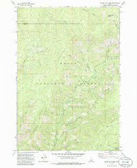
1972 Map of Miller Mtn West
USGS Topo · Published 1986About this map
The Boise National Forest defines the rugged geography of this 1972 survey, centered on the high elevations of Deadwood Ridge and Miller Mountain. This area in central Idaho is characterized by a dense network of watercourses, including Whitehawk Creek and Deadwood Creek, which drain the steep slopes that define the border between Valley and Boise counties. The absence of modernized roads is striking, with human passage marked instead by a traditional Pack Trail winding through the eastern portion of the quadrangle.
Find a feature on this map
27 named features on this map. Tap any name to fly to it.
Don’t see what you’re looking for? This feature index may not catch every label — zoom into the map to look around manually.
Map Details
Editions of this 1972 Miller Mtn West Map
2 editions found
Other maps of this area

1891 · Bear Valley
USGS Topo · 1:125,000

1893 · Bear Valley
USGS Topo · 1:125,000

1909 · Garden Valley
USGS Topo · 1:125,000

1953 · Deadwood Reservoir
USGS Topo · 1:62,500

1957 · Challis
USGS Topo · 1:250,000

1960 · Challis
USGS Topo · 1:250,000

1963 · Challis
USGS Topo · 1:250,000

1972 · Cache Creek
USGS Topo · 1:24,000
1972 · Miller Mtn East
USGS Topo · 1:24,000

1972 · Scott Creek
USGS Topo · 1:24,000