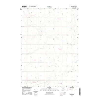
2015 Map of Miller NW
USGS Topo · Published 2015About this map
Wolf Cr and Shaefer Cr meander through this rural section of the Missouri Plateau, defining the subtle drainage patterns of the Dakota prairie. The landscape is organized by a strict section-line road grid, where unpaved routes such as 183rd St and 361st Ave intersect at regular intervals to serve isolated farmsteads and agricultural tracts. This 2015 survey reflects a classic Great Plains land-use pattern, with the central flow of Lost Cr bisecting the quadrangle. The lack of concentrated settlements highlights the vast, open character of Hand County, where the topography is defined more by its creek beds and section boundaries like t115n r67w than by urban development.
Find a feature on this map
22 named features on this map. Tap any name to fly to it.
Don’t see what you’re looking for? This feature index may not catch every label — zoom into the map to look around manually.
Map Details
Editions of this 2015 Miller NW Map
This is the sole edition of this map. No revisions or reprints were ever made.
Other maps of this area

1899 · Redfield
USGS Topo · 1:125,000

1950 · Ree Heights SE
USGS Topo · 1:24,000

1951 · Polo
USGS Topo · 1:24,000

1951 · Ree Heights NE
USGS Topo · 1:24,000

1953 · Huron
USGS Topo · 1:250,000

1954 · Huron
USGS Topo · 1:250,000

1966 · Burdette
USGS Topo · 1:24,000
1966 · Rockham SW
USGS Topo · 1:24,000
1966 · Rockham SE
USGS Topo · 1:24,000

1967 · Miller
USGS Topo · 1:24,000