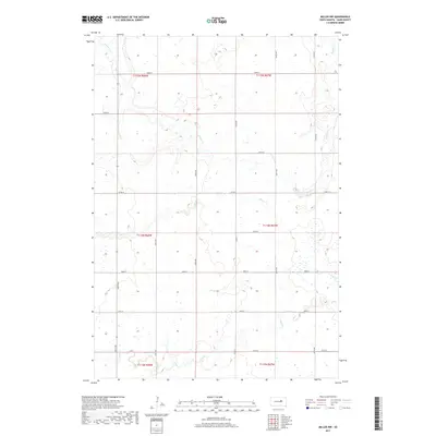
2017 Map of Miller NW
USGS Topo · Published 2017About this map
Shaefer Cr and Lost Cr define the hydrological character of this Hand County landscape, where the prairie is carved by seasonal drainage patterns. This 2017 survey reflects the enduring grid of the Public Land Survey System, with township and range lines such as t114n r68w and t115n r67w organizing the rural space. The terrain is marked by numerous small wetlands and depressions typical of the regional topography, which influence the placement of the local road network. Secondary routes including Co Rd 17 and a series of numbered section-line roads like 185th St and 188th St provide the primary access to the agricultural parcels. To the south, the meandering path of Wolf Cr cuts through the lower townships, providing a clear visual record of the natural watershed before it reaches more developed areas.
Find a feature on this map
18 named features on this map. Tap any name to fly to it.
Don’t see what you’re looking for? This feature index may not catch every label — zoom into the map to look around manually.
Map Details
Editions of this 2017 Miller NW Map
This is the sole edition of this map. No revisions or reprints were ever made.
Other maps of this area

1899 · Redfield
USGS Topo · 1:125,000

1950 · Ree Heights SE
USGS Topo · 1:24,000

1951 · Polo
USGS Topo · 1:24,000

1951 · Ree Heights NE
USGS Topo · 1:24,000

1953 · Huron
USGS Topo · 1:250,000

1954 · Huron
USGS Topo · 1:250,000

1966 · Burdette
USGS Topo · 1:24,000
1966 · Rockham SW
USGS Topo · 1:24,000
1966 · Rockham SE
USGS Topo · 1:24,000

1967 · Miller
USGS Topo · 1:24,000