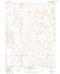
1965 Map of Miller Ranch
USGS Topo · Published 1984About this map
The agricultural and energy landscape of Morgan County is defined by the winding course of Beaver Creek and a complex irrigation network including the Upper Platte and Beaver Canal and Morgan Canal. This mid-century survey captures a region where water management was essential for the survival of the High Plains ranching economy. Centered on the Miller Ranch and the junction at Ninemile Corner, the map reveals a countryside punctuated by dozens of individually named windmills, such as the School Section Windmill and Mitchell Windmills, which indicate the critical importance of groundwater access.
Find a feature on this map
25 named features on this map. Tap any name to fly to it.
Don’t see what you’re looking for? This feature index may not catch every label — zoom into the map to look around manually.
Map Details
Editions of this 1965 Miller Ranch Map
3 editions found
Other maps of this area

1951 · Brush West
USGS Topo · 1:24,000

1951 · Merino SW
USGS Topo · 1:24,000

1951 · Brush East
USGS Topo · 1:24,000

1954 · Sterling
USGS Topo · 1:250,000

1958 · Sterling
USGS Topo · 1:250,000

1963 · Round Top
USGS Topo · 1:24,000

1965 · Gary
USGS Topo · 1:24,000

1965 · Huey Ranch
USGS Topo · 1:24,000

1965 · Miller Ranch
USGS Topo · 1:24,000

1971 · Brush East
USGS Topo · 1:24,000