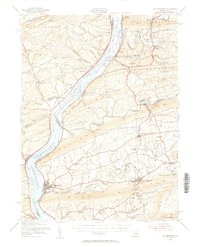
1953 Map of Millersburg
USGS Topo · Published 1956About this map
The Susquehanna River dominates this mid-century landscape, carving a wide path through the ridges of central Pennsylvania. The river is dotted with named islands like Hoover Island and Browns Island, while an Abandoned Canal traces the western bank, a relic of earlier transportation networks. Settlements like Millersburg and Elizabethville serve as hubs for the surrounding valleys, which are densely populated with family-named schools and small rural parishes.
Find a feature on this map
107 named features on this map. Tap any name to fly to it.
Don’t see what you’re looking for? This feature index may not catch every label — zoom into the map to look around manually.
Map Details
Editions of this 1953 Millersburg Map
3 editions found
Other maps of this area

1892 · Lykens
USGS Topo · 1:62,500

1892 · Hummelstown
USGS Topo · 1:62,500

1892 · Shamokin
USGS Topo · 1:62,500

1892 · Harrisburg
USGS Topo · 1:62,500

1893 · Sunbury
USGS Topo · 1:62,500

1893 · Lykens
USGS Topo · 1:62,500

1893 · Shamokin
USGS Topo · 1:62,500

1893 · Millersburg
USGS Topo · 1:62,500

1899 · Harrisburg
USGS Topo · 1:62,500

1907 · New Bloomfield
USGS Topo · 1:62,500