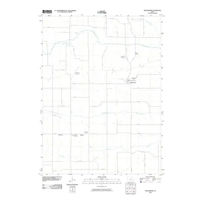
2010 Map of Millersburg
USGS Topo · Published 2010About this map
The North English River and Middle English River define the rural topography of this Iowa County landscape, where small crossroads settlements and family burial grounds reflect generations of agricultural life. The town of Millersburg serves as a central hub, anchored by the Millersburg Post Office and Millersburg Cemetery. To the south, the community of Ambrose and the settlement of Armah are joined by the Ambrose Catholic Armah Cemetery, illustrating the clustered nature of early Iowa townships. The map is notable for its high density of established cemeteries, including Saint Bernards Cemetery, Dedmore Cemetery, Mount Zion Cemetery, and the Community Cemetery. These sites, along with a grid of section roads and the winding course of Gritter Creek, provide a detailed view of the regional drainage patterns and the persistent boundaries of the prairie homesteads in the early twenty-first century.
Find a feature on this map
43 named features on this map. Tap any name to fly to it.
Don’t see what you’re looking for? This feature index may not catch every label — zoom into the map to look around manually.
Map Details
Editions of this 2010 Millersburg Map
This is the sole edition of this map. No revisions or reprints were ever made.
Other maps of this area

1954 · Des Moines
USGS Topo · 1:250,000

1956 · Des Moines
USGS Topo · 1:250,000

1957 · Des Moines
USGS Topo · 1:250,000

1965 · What Cheer
USGS Topo · 1:24,000

1965 · Keswick
USGS Topo · 1:24,000

1965 · South English
USGS Topo · 1:24,000

1968 · Deep River
USGS Topo · 1:24,000
1968 · North English
USGS Topo · 1:24,000
1968 · Williamsburg
USGS Topo · 1:24,000

1968 · Victor
USGS Topo · 1:24,000