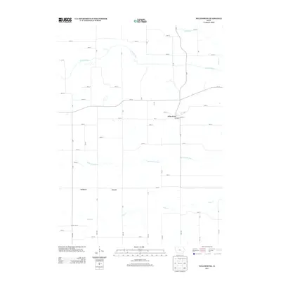
2013 Map of Millersburg
USGS Topo · Published 2013About this map
Millersburg serves as the primary hub in this portion of Iowa County, situated at the junction of several local routes including Main St and Jackson St. The landscape is defined by its drainage patterns, with the N English River winding across the northern section and the Middle English River cutting through the center. Small rural locales like Ambrose and Armah are situated along the south-central roads, reflecting the dispersed agricultural settlement pattern of the region. The grid of section roads, such as 105th St and 300th St, provides access to the interior farmsteads. Smaller watercourses like Gritter Cr and the descriptively named Devils Run feed into the larger river systems, illustrating the local topography before these streams exit the quadrangle.
Find a feature on this map
52 named features on this map. Tap any name to fly to it.
Don’t see what you’re looking for? This feature index may not catch every label — zoom into the map to look around manually.
Map Details
Editions of this 2013 Millersburg Map
This is the sole edition of this map. No revisions or reprints were ever made.
Other maps of this area

1954 · Des Moines
USGS Topo · 1:250,000

1956 · Des Moines
USGS Topo · 1:250,000

1957 · Des Moines
USGS Topo · 1:250,000

1965 · What Cheer
USGS Topo · 1:24,000

1965 · Keswick
USGS Topo · 1:24,000

1965 · South English
USGS Topo · 1:24,000

1968 · Deep River
USGS Topo · 1:24,000
1968 · North English
USGS Topo · 1:24,000
1968 · Williamsburg
USGS Topo · 1:24,000

1968 · Victor
USGS Topo · 1:24,000