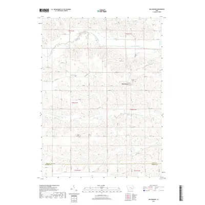
2018 Map of Millersburg
USGS Topo · Published 2018About this map
Millersburg anchors the center of this eastern Iowa landscape, situated at the junction of Main St and Jackson St. The surrounding countryside is defined by the branching paths of the North English River and Middle English River, which carve through the Iowa County terrain toward the Keokuk County line. For those tracing local heritage, the map is remarkably dense with burial grounds, ranging from the Ambrose Catholic Armah Cem in the south to Saint Bernards Cem and the Dedmore Cem further north. This concentration of cemeteries, including the centrally located Millersburg Cem and the more isolated Community Cem, suggests a long-standing rural community structure tied to early township settlements. The land follows a grid of gravel and paved routes like Co Hwy F52, occasionally interrupted by the winding courses of Gritter Cr and Devils Run.
Find a feature on this map
42 named features on this map. Tap any name to fly to it.
Don’t see what you’re looking for? This feature index may not catch every label — zoom into the map to look around manually.
Map Details
Editions of this 2018 Millersburg Map
This is the sole edition of this map. No revisions or reprints were ever made.
Other maps of this area

1954 · Des Moines
USGS Topo · 1:250,000

1956 · Des Moines
USGS Topo · 1:250,000

1957 · Des Moines
USGS Topo · 1:250,000

1965 · What Cheer
USGS Topo · 1:24,000

1965 · Keswick
USGS Topo · 1:24,000

1965 · South English
USGS Topo · 1:24,000

1968 · Deep River
USGS Topo · 1:24,000
1968 · North English
USGS Topo · 1:24,000
1968 · Williamsburg
USGS Topo · 1:24,000

1968 · Victor
USGS Topo · 1:24,000