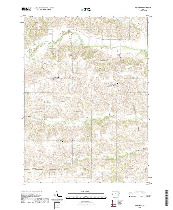
2022 Map of Millersburg
USGS Topo · Published 2022About this map
Millersburg serves as the central hub of this agricultural landscape, where the town grid is defined by Main St and Jackson St. The surrounding countryside is defined by the parallel courses of the North English River and the Middle English River, which carve subtle valleys through the farmland of northwestern Iowa County and Keokuk County. Local history is preserved in several small burial grounds scattered across the townships, including Saint Bernards Cem, Dedmore Cem, and the Armah Cem near the southern boundary. These cemeteries, alongside landmarks like Mount Zion Cem and Community Cem, trace the generational footprint of rural families. The map also captures the drainage patterns of smaller tributaries such as Gritter Cr and Devils Run, illustrating the vital role of water management in this heartland region.
Find a feature on this map
41 named features on this map. Tap any name to fly to it.
Don’t see what you’re looking for? This feature index may not catch every label — zoom into the map to look around manually.
Map Details
Editions of this 2022 Millersburg Map
This is the sole edition of this map. No revisions or reprints were ever made.
Other maps of this area

1954 · Des Moines
USGS Topo · 1:250,000

1956 · Des Moines
USGS Topo · 1:250,000

1957 · Des Moines
USGS Topo · 1:250,000

1965 · What Cheer
USGS Topo · 1:24,000

1965 · Keswick
USGS Topo · 1:24,000

1965 · South English
USGS Topo · 1:24,000

1968 · Deep River
USGS Topo · 1:24,000
1968 · North English
USGS Topo · 1:24,000
1968 · Williamsburg
USGS Topo · 1:24,000

1968 · Victor
USGS Topo · 1:24,000