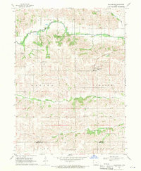
1968 Map of Millersburg
USGS Topo · Published 1971About this map
Millersburg serves as the primary hub for this late-1960s Iowa landscape, where the agricultural grid is deeply carved by a network of waterways. The North English River and Middle English River define the terrain's character, joined by smaller tributaries like Devils Run and Gritter Creek. This survey reveals a community anchored by rural institutions, including St Bernards Cath Ch and the Community Ch. Further south, the boundary between Iowa Co and Keokuk Co cuts across the rural landscape near Armah Ch. Genealogists may find value in the location of the Mt Zion Cem and other local burial grounds, which highlight the early settlement patterns within Pilot and Dayton townships. The map illustrates a period of established family farms and local parishes before modern agricultural consolidation significantly altered the rural social fabric.
Find a feature on this map
17 named features on this map. Tap any name to fly to it.
Don’t see what you’re looking for? This feature index may not catch every label — zoom into the map to look around manually.
Map Details
Editions of this 1968 Millersburg Map
This is the sole edition of this map. No revisions or reprints were ever made.
Other maps of this area

1954 · Des Moines
USGS Topo · 1:250,000

1956 · Des Moines
USGS Topo · 1:250,000

1957 · Des Moines
USGS Topo · 1:250,000

1965 · What Cheer
USGS Topo · 1:24,000

1965 · Keswick
USGS Topo · 1:24,000

1965 · South English
USGS Topo · 1:24,000

1968 · Deep River
USGS Topo · 1:24,000
1968 · North English
USGS Topo · 1:24,000
1968 · Williamsburg
USGS Topo · 1:24,000

1968 · Victor
USGS Topo · 1:24,000