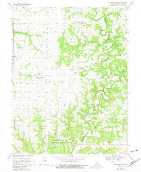
1969 Map of Millersburg SW
USGS Topo · Published 1982About this map
Cedar Creek meanders along the Boone and Callaway County line, carving through a landscape defined by significant woodland research areas and aviation development. The southern portion of the map is dominated by the University of Missouri Ashland Wildlife Research Area, which includes specific infrastructure such as the Laboratory Dam and Spillway. To the west, the mid-century expansion of the region is evident in the sprawling grounds of the Columbia Regional Airport near Englewood.
Find a feature on this map
46 named features on this map. Tap any name to fly to it.
Don’t see what you’re looking for? This feature index may not catch every label — zoom into the map to look around manually.
Map Details
Editions of this 1969 Millersburg SW Map
4 editions found
Other maps of this area

1886 · Jefferson City
USGS Topo · 1:125,000

1894 · Jefferson City
USGS Topo · 1:125,000

1935 · Columbia
USGS Topo · 1:24,000

1939 · Jefferson City
USGS Topo · 1:62,500

1940 · Columbia
USGS Topo · 1:24,000

1942 · Jefferson City
USGS Topo · 1:62,500

1944 · Millersburg
USGS Topo · 1:62,500

1946 · Millersburg
USGS Topo · 1:62,500

1947 · Jefferson City
USGS Topo · 1:250,000

1948 · Centertown
USGS Topo · 1:62,500