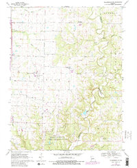
1969 Map of Millersburg SW
USGS Topo · Published 1982About this map
Columbia Regional Airport anchors the central landscape of this 1969 survey, marking a period of modern infrastructure expansion alongside long-established rural settlements like Deer Park and Englewood. The terrain is defined by the winding course of Cedar Creek, which serves as the county line between Boone Co and Callaway Co. This drainage system creates notable topographic features such as the Devils Backbone and Mill Site Bluff, while the southern reaches are dominated by the University of Missouri Ashland Wildlife Research Area, complete with its Laboratory Dam and designated spillways. Small family and community landmarks, including the Harris Cem, Barger Cem, and Barnes Chapel, are scattered along country routes like Blind Lane and Craig Lane, preserving the genealogy of the Cedar and Bourbon townships during the late twentieth century.
Find a feature on this map
43 named features on this map. Tap any name to fly to it.
Don’t see what you’re looking for? This feature index may not catch every label — zoom into the map to look around manually.
Map Details
Editions of this 1969 Millersburg SW Map
4 editions found
Other maps of this area

1886 · Jefferson City
USGS Topo · 1:125,000

1894 · Jefferson City
USGS Topo · 1:125,000

1935 · Columbia
USGS Topo · 1:24,000

1939 · Jefferson City
USGS Topo · 1:62,500

1940 · Columbia
USGS Topo · 1:24,000

1942 · Jefferson City
USGS Topo · 1:62,500

1944 · Millersburg
USGS Topo · 1:62,500

1946 · Millersburg
USGS Topo · 1:62,500

1947 · Jefferson City
USGS Topo · 1:250,000

1948 · Centertown
USGS Topo · 1:62,500