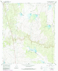
1967 Map of Millersview SE
USGS Topo · Published 1988About this map
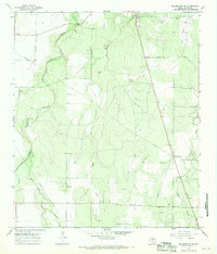
The Brady Mountains rise as a prominent limestone upland in this 1967 survey of Concho County, Texas. This landscape is defined by the headwaters of the Colorado River drainage system, including the serpentine paths of Duck Creek and Maverick Creek. The map documents a sparsely populated ranching territory where local industry is represented primarily by numerous Gravel Pits scattered along the drainages. Revisions from 1983 aerial photography reveal a series of flood control structures and risers built into the network of the West Fork Mustang Creek and the Middle Fork Mustang Creek, showing the mid-century evolution of water management in the Edwards Plateau region. These small-scale reservoirs provide a distinct contrast to the surrounding arid terrain and established transit routes like Highway 83.
Find a feature on this map
8 named features on this map. Tap any name to fly to it.
Don’t see what you’re looking for? This feature index may not catch every label — zoom into the map to look around manually.
Map Details
Editions of this 1967 Millersview SE Map
2 editions found
Other maps of this area

1892 · Eden
USGS Topo · 1:125,000

1896 · Eden
USGS Topo · 1:125,000

1931 · Stacy
USGS Topo · 1:62,500

1954 · Brownwood
USGS Topo · 1:250,000

1967 · Millersview SE
USGS Topo · 1:24,000
1967 · Millersview
USGS Topo · 1:24,000
1967 · Doole SW
USGS Topo · 1:24,000
1967 · Mustang Creek
USGS Topo · 1:24,000
1967 · Millersview NW
USGS Topo · 1:24,000
1967 · Millersview SW
USGS Topo · 1:24,000