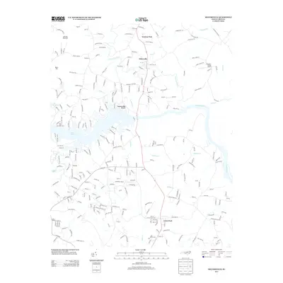
2013 Map of Millersville
USGS Topo · Published 2013About this map
The Catawba River and its expansive reservoir at Lake Hickory define the landscape of this region north of Hickory. The map illustrates a transition from the developing residential edges of Saint Stephens to the more rural, stream-dissected terrain of Alexander County. Settlement patterns follow the winding course of the Lower Little River, with small communities like Millersville and Taylorsville Beach serving as local focal points. The topography is shaped by prominent rises such as Barrett Mountain and Buck Hill, which overlook a network of creek valleys including Elk Shoal Cr and Naked Cr. Local aviation and recreation are represented by the Alexander County Airport and the riverside Oxford Park, while the Grace and Truth Bible Camp occupies a prominent position on the shoreline. The road network, including Alspaugh Dam Rd and Teague Town Rd, reflects a history of small farms and family-held tracts across the rolling North Carolina Piedmont.
Find a feature on this map
252 named features on this map. Tap any name to fly to it.
Don’t see what you’re looking for? This feature index may not catch every label — zoom into the map to look around manually.
Map Details
Editions of this 2013 Millersville Map
This is the sole edition of this map. No revisions or reprints were ever made.
Other maps of this area

1895 · Hickory
USGS Topo · 1:125,000

1953 · Charlotte
USGS Topo · 1:250,000

1954 · Charlotte
USGS Topo · 1:250,000

1960 · Charlotte
USGS Topo · 1:250,000

1962 · Charlotte
USGS Topo · 1:250,000
1970 · Hiddenite
USGS Topo · 1:24,000

1970 · Bethlehem
USGS Topo · 1:24,000

1970 · Newton
USGS Topo · 1:24,000
1970 · Catawba
USGS Topo · 1:24,000
1970 · Ellendale
USGS Topo · 1:24,000