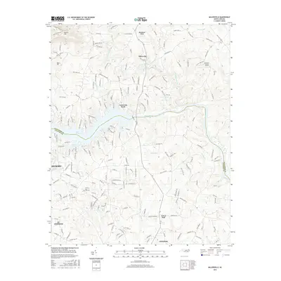
2016 Map of Millersville
USGS Topo · Published 2016About this map
Lake Hickory and the Catawba River dominate the central landscape of this 2016 survey, where the waters divide Alexander and Catawba counties. The shoreline is densely populated with developments like Taylorsville Beach and Reitzel Cove, reflecting the mid-twentieth-century transformation of the river valley into a residential and recreational hub. To the north, the terrain rises toward Barrett Mtn and Buck Hill, where older rural road patterns like Millersville Rd and Hines Farm Rd persist alongside the village of Millersville. For those searching for family history, the map identifies local landmarks such as Saint Lukes Cem and Alexander County Airport, while the southern reaches show the steady expansion of Hickory, St. Stephens, and Conover. Numerous small tributaries, including Elk Shoal Cr and Naked Cr, continue to define the drainage patterns that shaped early settlement in this Piedmont region.
Find a feature on this map
179 named features on this map. Tap any name to fly to it.
Don’t see what you’re looking for? This feature index may not catch every label — zoom into the map to look around manually.
Map Details
Editions of this 2016 Millersville Map
This is the sole edition of this map. No revisions or reprints were ever made.
Other maps of this area

1895 · Hickory
USGS Topo · 1:125,000

1953 · Charlotte
USGS Topo · 1:250,000

1954 · Charlotte
USGS Topo · 1:250,000

1960 · Charlotte
USGS Topo · 1:250,000

1962 · Charlotte
USGS Topo · 1:250,000
1970 · Hiddenite
USGS Topo · 1:24,000

1970 · Bethlehem
USGS Topo · 1:24,000

1970 · Newton
USGS Topo · 1:24,000
1970 · Catawba
USGS Topo · 1:24,000
1970 · Ellendale
USGS Topo · 1:24,000