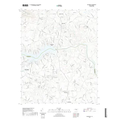
2019 Map of Millersville
USGS Topo · Published 2019About this map
The Catawba River serves as the dividing line between Alexander and Catawba Counties, forming the expansive Lake Hickory and its many inlets such as Reitzel Cove and Naked Cr. This 2019 survey documents the suburban landscape at the edges of Hickory and Conover, where modern developments like Oxford Park meet older landmarks. To the north, the terrain rises toward Barrett Mtn and Buck Hill, overlooking the Alexander County Airport and the community of Millersville. Local history is anchored by sites such as Saint Lukes Cem and Isenhour Park, while the hydrology is defined by the complex network of creeks including the Lower Little River and Elk Shoal Cr. The map details a transition from the dense residential grid in the south to the more dispersed settlements of Taylorsville Beach along the northern shore.
Find a feature on this map
190 named features on this map. Tap any name to fly to it.
Don’t see what you’re looking for? This feature index may not catch every label — zoom into the map to look around manually.
Map Details
Editions of this 2019 Millersville Map
This is the sole edition of this map. No revisions or reprints were ever made.
Other maps of this area

1895 · Hickory
USGS Topo · 1:125,000

1953 · Charlotte
USGS Topo · 1:250,000

1954 · Charlotte
USGS Topo · 1:250,000

1960 · Charlotte
USGS Topo · 1:250,000

1962 · Charlotte
USGS Topo · 1:250,000
1970 · Hiddenite
USGS Topo · 1:24,000

1970 · Bethlehem
USGS Topo · 1:24,000

1970 · Newton
USGS Topo · 1:24,000
1970 · Catawba
USGS Topo · 1:24,000
1970 · Ellendale
USGS Topo · 1:24,000